Map Visualization
To let developers easily understand and use the environment they scanned better, we introduce the map visualization feature.
Visualization on the Unity Editor
- Setup Pretia SDK: Step by Step Guideline
- Similar feature: Map Visualization on the Developer Console
If the developer has already created some maps from the 3D Scanner App, those maps will be available to be imported from this menu.
This is a preview of the Map Download window.
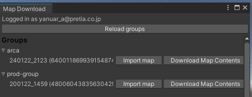
After pressing one of the Import map buttons, the Editor will create a folder hierarchy under Assets > Pretia > MapGroups. This folder will contain all the maps that have been imported. After the import is finished, it will create a prefab automatically inside the MapGroups folder. This prefab will contain some meshes that will represent the detected planes of the scanned area, and also anchors if there are any.
This is a preview of the imported map.

Map Anchors
A map anchor is a visual guide that helps developers place 3D content on a map. A map anchor is only created at mapping phases, that is when using the 3D scanner.
What’s different from Shared Anchors
| Shared Anchors | Map Anchors | |
| Number | only one per map | could be multiple per map |
| Anchor Position | developers cannot decide the position | developers decide the position |
- Note: refer to Shared Anchors